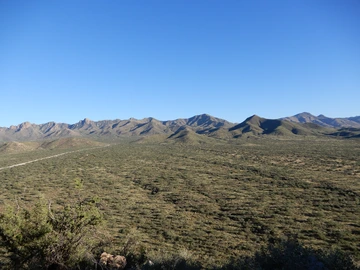
View on the Santa Rita Range from the Huerfano Butte
Founded in 1902 as the first experimental range to understand the ecosystem and apply sustainable management practices, the Santa Rita Experimental Range (SRER) is the longest continuously active rangeland research facility and among the five oldest biological field stations in the United States. Located 35 miles south of Tucson in Pima County, Arizona, at the foot of the northwestern edge of the Santa Rita Mountains, the 52,000-acre range was administered by the United States Forest Service until 1987, when the University of Arizona College of Agriculture took over the administration of the site.
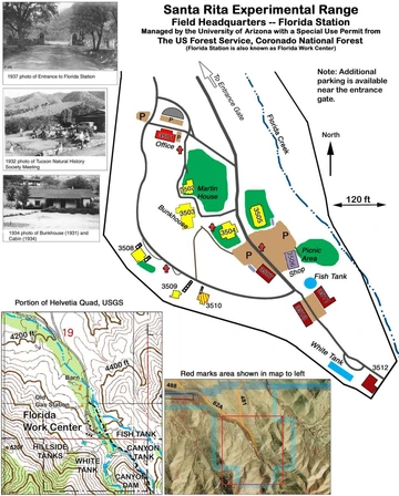
The Florida Station, located in the Florida Canyon of the Santa Rita Mountains, is the SRER headquarters. It now hosts the SRER managers and, with facilities, serves as a base location for educational activities and for researchers working on the range.
Learn more about the Range and the Florida Station in the sections below and visit History for more information about the SRER foundation.

Location of the SRER
Medina 1996
The Santa Rita Experimental Range (adapted from Medina 1996)
The SRER is about 35 miles south of Tucson in Pima County, Arizona, at the foot of the northwestern edge of the Santa Rita Mountains. It is characterized by small areas of steep, stony foothills and a few isolated buttes, but the greater part consists of long, gently sloping alluvial fans. Across the 900-1450 m elevation range, precipitation on the Santa Rita ranges from 275-450 mm y-1, and Sonoran Desertscrub, Semi-Desert Grassland, and Madrean Evergreen Woodland biotic communities appear in ascending order (McClaran 2003). When included with the nearby Santa Cruz River and adjacent Coronado National Forest, the Santa Rita is part of a continuous 889–2881 m elevation gradient that includes riparian and coniferous forest communities. The flora includes 468 species in 80 families (Medina 2003), including a federal endangered cactus species (Coryphantha scheeri var. robustispina). Over 90 vertebrates are known (Krausman and Morrison 2003).
The geology varies from simple strata of recent deposits of alluvium to extensive thrust faulting. Alluvial caps cover about 95% of the area. These gravel strata vary in thickness from about 400 feet in higher elevations to well over 2,000 feet in the lower parts. Small outcrops of granodiorite, limestone, sandstone, and other conglomerates constitute the remaining 5%.
There are 32 mapped soil series with ages ranging from recent Holocene to Early Pleistocene, and geomorphic surfaces vary from mountain, to alluvial fan, and flood plain (Breckenfeld and Robinett 2003). In addition, there are 21 mapped Ecological Sites (Breckenfeld and Robinett 2003).
Major vegetation changes have occurred in the range since the early 1900's. Velvet mesquite (Prosopis velutina) is the dominant overstory species on 20,000-30,000 acres where shrub-free grassland dominated before 1900. Mesquite and prickly pear cactus are major species above 4,000 feet, but other species including acacia (Acacia greggii, A. angustissima), mimosa (Mimosa biuncifera, M. dysocarpa), and false mesquite (Calliandra eriophylla) comprise 65% of the cover at this elevation. Mesquite, burroweed (Haplopappus tenuisectus), and cholla cactus (Opuntia fulgida, O. spinosior, and O. versicolor) attain highest densities between 3,200 and 3,600 feet elevation (Martin and Reynolds 1973).
Species composition of perennial grasses changes with elevation and rainfall (Martin and Reynolds 1973). Santa Rita threeawn (Aristida glabrata), Rothrock grama (Bouteloua rothrockii), and bush muhly (Muhlenbergia porteri) are important species of middle and lower elevations. Various species of gramas (Bouteloua eriopoda, B. curtipendula, B. filiformis, B. chondrosioides, B. hirsuta) are widely distributed at higher elevations. Arizona cottontop (Digitaria californica) and species of threeawns (Aristida spp.) are common at all elevations. The non-native Lehmann lovegrass (Eragrostis lehmanniana) is the most common perennial grass species (McClaran 2003, from Centennial Proceedings). See Appendix C and Flora for a complete list of plant species found on SRER.
Since its institution, the SRER has offered unique opportunities for research, education, and outreach, as well as for recreation.
Researchers are encouraged to learn more about the DATA RESOURCES available for download and the opportunities for RESEARCH. Moreover, the list of most recent publications as well as the Annotated Bibliography (1903 - 1988) can be downloaded from this website.
Hunting, hiking, camping, nature studies, and bird watching are the principal recreational activities offered by the range.
If you are planning to visit the SRER, check in advance Visiting for more information about safety and rules of behavior.
References
Breckenfeld, Donald J.; Robinett, Daniel.2003. Soil and Ecological Sites of the Santa Rita Experimental Range. In: McClaran, Mitchel P.; Ffolliott, Peter F.; Edminster, Carleton B., tech. coords. Santa Rita Experimental Range: 100 years (1903 to 2003) of accomplishments and contributions; conference proceedings; 2003 October 30–November 1; Tucson, AZ. Proc. RMRS-P-30. Ogden, UT: U.S. Department of Agriculture, Forest Service, Rocky Mountain Research Station. p. 157-165.
Krausman, Paul R.; Morrison, Michael L. 2003. Wildlife Ecology and Management, Santa Rita Experimental Range (1903 to 2002). In: McClaran, Mitchel P.; Ffolliott, Peter F.; Edminster, Carleton B., tech. coords. Santa Rita Experimental Range: 100 years (1903 to 2003) of accomplishments and contributions; conference proceedings; 2003 October 30–November 1; Tucson, AZ. Proc. RMRS-P-30. Ogden, UT: U.S. Department of Agriculture, Forest Service, Rocky Mountain Research Station. p. 60-67.
Martin, S. Clark; Reynolds, Hudson G. 1973. The Santa Rita Experimental Range: Your facility for research on semidesert ecosystems. Journal of the Arizona Academy of Science. 8: 56-67.
McClaran, Mitchel P. 2003. A Century of Vegetation Change on the Santa Rita Experimental Range. In: McClaran, Mitchel P.; Ffolliott, Peter F.; Edminster, Carleton B., tech. coords. Santa Rita Experimental Range: 100 years (1903 to 2003) of accomplishments and contributions; conference proceedings; 2003 October 30–November 1; Tucson, AZ. Proc. RMRS-P-30. Ogden, UT: U.S. Department of Agriculture, Forest Service, Rocky Mountain Research Station. p. 16-33.
Medina, Alvin L. 1996. The Santa Rita Experimental Range: History and Annotated Bibliography (1903-1988). General Technical Report RM-GTR-276 Rocky Mountain Forest and Range Experiment Station Forest Service U.S. Department of Agriculture. 67 p.

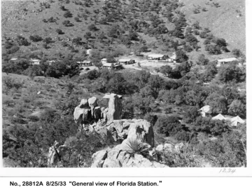
Florida Station overview in 1933
Santa Rita Experimental Range Archives
The Florida Station, located in the Florida Canyon of the Santa Rita Mountains, is the SRER headquarters. It was built mainly between 1923 and 1934. A detailed description of the early years of the Florida Station by Gillespie (2003) is available on the Pima County website.

The Station was restored in 2010 with the help of federal funding. It now consists of 16 buildings including a bunkhouse, two cabins, and an education center.
All facilities are available to researchers upon reservation.
References
Gillespie, William. B. 2003. Early Years of the Santa Rita Experimental Range and Florida Station. Pima County GIS Library Contents - Metadata

